Saturday June 23
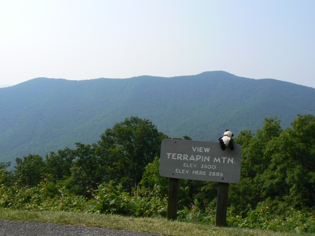
Today was divided between preparing for tomorrows departure into the Smokies, and a drive to the south of Asheville. The first destination, which was really more of an excuse for a country drive (besides being South Carolina's highest point), was Sassafras Mountain, South Carolina. Read the link, it's a decent description of what to expect. (My consolation is that I already knew what the view from there would be like.)
I also stopped in Hendersonville, NC, especially since I spotted some ice cream on a hot day. It also happens to be a place my parents occasionally visit, since it has a change ringing setup in one of its church towers.
Dinner was provided by an uninspired waitress at a largish Mexican restaurant. The food was filling and cheap, but also uninspired.
Thursday, June 28, 2007
Saturday, June 23, 2007
Asheville and Mount Mitchell
Thursday June 21
This day was partly a logistics day. Some necessary shopping, some supplies for at least tomorrow's assault on Mount Mitchell. I also visited the Folk Arts Center, which has nice displays and sales of contemporary regional folk arts, and a cool display on the design and construction of the Blue Ridge Parkway, going into some detail on the design principles that make the road as attractive as it is. I then drove on to Black Mountain, a small town outside Asheville with a one-street walkable downtown. Good for lunch, a haircut, and the necessary purchase of cooking gas for the upcoming trek into the Smokies.
Dinner was at the Laughing Seed Cafe, a place definitely Russell-unfriendly. Which means I liked it.
Friday June 22
This morning featured a hike up the highest mountain east of the Mississippi. Mount Mitchell is, amazingly enough, not on the Appalachian Trail, but it has lovely views out to the Smokies.
 Unfortunately, the very top of the summit was closed off due to the reconstruction of the observation platform.
Did I mention there was a road up to the summit area, and a concession stand? I actually hiked from further down, near where the access road meets the Blue Ridge Parkway. The trail featured some nice (if slightly after-peak) rhododendrons.

Dinner was at the Ophelia's World Cafe. It was good, but I really liked the other places I've eaten better.
Next update will not be until probably next Thursday, due to four-day hike into the Smokies.
Happy Trails!
This day was partly a logistics day. Some necessary shopping, some supplies for at least tomorrow's assault on Mount Mitchell. I also visited the Folk Arts Center, which has nice displays and sales of contemporary regional folk arts, and a cool display on the design and construction of the Blue Ridge Parkway, going into some detail on the design principles that make the road as attractive as it is. I then drove on to Black Mountain, a small town outside Asheville with a one-street walkable downtown. Good for lunch, a haircut, and the necessary purchase of cooking gas for the upcoming trek into the Smokies.
Dinner was at the Laughing Seed Cafe, a place definitely Russell-unfriendly. Which means I liked it.
Friday June 22
This morning featured a hike up the highest mountain east of the Mississippi. Mount Mitchell is, amazingly enough, not on the Appalachian Trail, but it has lovely views out to the Smokies.

 Unfortunately, the very top of the summit was closed off due to the reconstruction of the observation platform.
Did I mention there was a road up to the summit area, and a concession stand? I actually hiked from further down, near where the access road meets the Blue Ridge Parkway. The trail featured some nice (if slightly after-peak) rhododendrons.


Dinner was at the Ophelia's World Cafe. It was good, but I really liked the other places I've eaten better.
Next update will not be until probably next Thursday, due to four-day hike into the Smokies.
Happy Trails!
Thursday, June 21, 2007
The beautiful Blue Ridge
Monday, June 18


Today I drove down a stretch of the Blue Ridge Parkway. This scenic road stretches from Northern Virginia to southwestern North Carolina. Today I drove about 100 miles, taking about 4 hours, including stops to enjoy views and such along the way. I made my way west along an extremely windy stretch of US 58 to Virginia's Grayson Highlands State Park.This gem of a park contains some nice open highlands, has facilities for camping and horseriding, and is also along the Appalachian Trail. I stayed in the campground for the night, but not before enjoying a spectacular sunset view from a point called (imaginatively enough) Little Pinnacle. Along the way I spotted rabbits and deer.
The park is adjacent to the Mount Rogers National Recreation Area, where I spent some time the next day.
Tuesday, June 19
This morning featured a bright and early start. Since a chance of thunderstorms was forecast for this afternoon, I thought it wise to tackle Mount Rogers early today. I actually managed to break camp and be at the trailhead by 7:15. I know, not impressive, unless you know how much I like getting up some mornings.


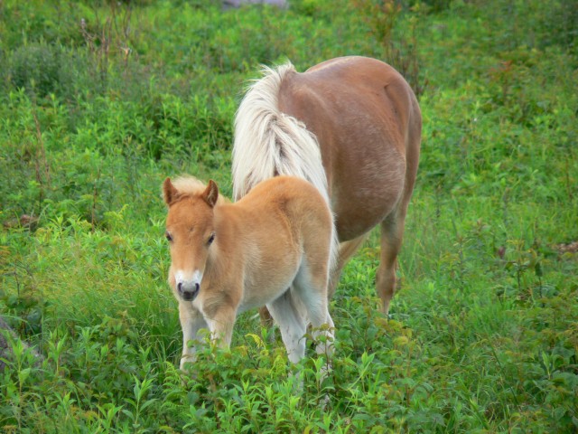
The hike to Mount Rogers (5729 feet, highest point in Virginia) was about 8 miles round trip, with about 1000 feet of elevation gained. Parts of the route are on the AT. The landscape was fairly open, often with views mostly in southerly directions. The primary large inhabitants of the area seem to be wild ponies, some of which were not shy at all. (At least they're not as dangerous as bear, which are also a presence along much of the Appalachians.) The summit of Rogers is wooded, but the whole rest of the hike was very pleasant.
The weather was overcast with pockets of sun and drizzle. I returned to my car around 11:30.
From Grayson Highlands, I drove further down the very twisty US 58 to Abingdon, VA, where I picked up I-81 and made my way on to Asheville, NC. After ensconcing in my hotel on the outer edge of town (and also napping), I headed downtown for dinner and ice cream. I find that Marble Slab serves pretty nice ice cream.
Wednesday, June 20
My first full day in the Asheville area, and time to do some research. I'm interested in hiking Mount Mitchell (highest point in the eastern US) and Clingman's Dome (scenic high point in the Smoky Mountains). I decide to drive more of the Blue Ridge Parkway toward the main NC entrance to Great Smoky Mountain National Park, to acquire maps and information about permitting. Along the way, I stop to summit Mount Pisgah (not to be confused with a church or a similarly named peak in Pennsylvania.) This was a short hike, 3 miles RT and 700 feet up to the summit.
 I met a middle-aged couple and his father, who had originally been on the summit 40 years before. They had interesting insights into the changes in the summit area (which features a TV transmission tower among other things).
Lunch was a southern affair at The Tupelo Honey Cafe. Toasted tomato and cheese sandwich with a side of fried okra. Yum.
Dinner was also a local affair, at the Early Girl Eatery. Once again Yum, but not much Russell-friendly here.


The park is adjacent to the Mount Rogers National Recreation Area, where I spent some time the next day.
Tuesday, June 19
This morning featured a bright and early start. Since a chance of thunderstorms was forecast for this afternoon, I thought it wise to tackle Mount Rogers early today. I actually managed to break camp and be at the trailhead by 7:15. I know, not impressive, unless you know how much I like getting up some mornings.


The hike to Mount Rogers (5729 feet, highest point in Virginia) was about 8 miles round trip, with about 1000 feet of elevation gained. Parts of the route are on the AT. The landscape was fairly open, often with views mostly in southerly directions. The primary large inhabitants of the area seem to be wild ponies, some of which were not shy at all. (At least they're not as dangerous as bear, which are also a presence along much of the Appalachians.) The summit of Rogers is wooded, but the whole rest of the hike was very pleasant.
The weather was overcast with pockets of sun and drizzle. I returned to my car around 11:30.
From Grayson Highlands, I drove further down the very twisty US 58 to Abingdon, VA, where I picked up I-81 and made my way on to Asheville, NC. After ensconcing in my hotel on the outer edge of town (and also napping), I headed downtown for dinner and ice cream. I find that Marble Slab serves pretty nice ice cream.
Wednesday, June 20
My first full day in the Asheville area, and time to do some research. I'm interested in hiking Mount Mitchell (highest point in the eastern US) and Clingman's Dome (scenic high point in the Smoky Mountains). I decide to drive more of the Blue Ridge Parkway toward the main NC entrance to Great Smoky Mountain National Park,
 to acquire maps and information about permitting. Along the way, I stop to summit Mount Pisgah (not to be confused with a church or a similarly named peak in Pennsylvania.) This was a short hike, 3 miles RT and 700 feet up to the summit.
 I met a middle-aged couple and his father, who had originally been on the summit 40 years before. They had interesting insights into the changes in the summit area (which features a TV transmission tower among other things).
Lunch was a southern affair at The Tupelo Honey Cafe. Toasted tomato and cheese sandwich with a side of fried okra. Yum.
Dinner was also a local affair, at the Early Girl Eatery. Once again Yum, but not much Russell-friendly here.
Monday, June 18, 2007
Driving down the Appalachians
Saturday, June 16
Leave Cambridge 9:45. Arrive Pine Grove Furnace State Park (PA) about 6:15. In between I noticed that Russell isn't the only one going to or through Newfoundland. (Newfoundland, PA is just east of Scranton.)
Unbeknownst to me, Pine Grove Furnace State Park is the semi-official 1/2-way point on the Appalachian Trail! I chatted with some through-hikers while there, and read the register. The camp store will give free 1/2 gallons of ice cream to anyone who can finish them (I think in some modest time period like 30 minutes or 1 hour.)
The reason for this state park's existence is that it was the site of an early iron works (18th century I believe). All that's left really is a large chimney-like structure.
Sunday, June 17
In the morning, I hiked up to a local vista (about 1 hour each way). The entire area is forested. After said hike, drove on to Gettysburg, about 25 miles away. Drove around the battlefield, which is studded with monuments and plaques show who did what to whom when, and where, as well as monuments placed by states or state-level organizations to commemorate their fallen. On both sides, of course.
From Gettysburg, drove on the Harper's Ferry, WV, where I wandered down to the river (Shenandoah, I believe) for a view and some lunch. Drove on (and on), eventually picking up I-81 down the Shenandoah Valley. Got off near Natural Bridge, spent the night at a campground just off the Blue Ridge Parkway.


Leave Cambridge 9:45. Arrive Pine Grove Furnace State Park (PA) about 6:15. In between I noticed that Russell isn't the only one going to or through Newfoundland. (Newfoundland, PA is just east of Scranton.)
Unbeknownst to me, Pine Grove Furnace State Park is the semi-official 1/2-way point on the Appalachian Trail! I chatted with some through-hikers while there, and read the register. The camp store will give free 1/2 gallons of ice cream to anyone who can finish them (I think in some modest time period like 30 minutes or 1 hour.)
The reason for this state park's existence is that it was the site of an early iron works (18th century I believe). All that's left really is a large chimney-like structure.
Sunday, June 17
In the morning, I hiked up to a local vista (about 1 hour each way).
 The entire area is forested. After said hike, drove on to Gettysburg, about 25 miles away. Drove around the battlefield, which is studded with monuments and plaques show who did what to whom when, and where, as well as monuments placed by states or state-level organizations to commemorate their fallen. On both sides, of course.
From Gettysburg, drove on the Harper's Ferry, WV, where I wandered down to the river (Shenandoah, I believe) for a view and some lunch. Drove on (and on), eventually picking up I-81 down the Shenandoah Valley. Got off near Natural Bridge, spent the night at a campground just off the Blue Ridge Parkway.

Monday, June 11, 2007
On the move again
Hi there, I'm back!
The upcoming adventure this time is of a different sort. I'm about to sell the Raving Manse, and move into a slightly cozier abode in a nearby town. As I am forced by the unfortunate juxtaposition of property closings to be homeless for a period of 3 1/2 weeks, I am availing myself of this homeless period to embark on a modest road trip. Destination: North Carolina
What's there? Oh, some mountains, I hear. Stay tuned.

Subscribe to:
Posts (Atom)
