Showing posts with label alpujarras. Show all posts

Sunday, August 14, 2005

Hiking Las Alpujarras, day 3 and return to Granada

The last day of the Las Alpujarras hike was fairly easy. Except for the almost getting lost part.

An early-morning walk downhill.


I estimated that I was about 1-1.5 hours outside Capileira when I camped. With a typically early start (great for avoiding heat), I made pretty good time, largely downhill. However, it soon became clear there were more trails and roads on the ground than on my map.

Don't you just love when that happens?

Well, signs sometimes help.


Of course, every once in a while the village would appear, little white houses dangling on the side of the ravine. Oh yes. The villages here are not at the *bottom* of the ravine, they are 1/3 to 1/2 way up the side. Go down too far, and you may end up going back up, something the 30lb pack was weighing in against.

I eventually found a friendly shepherd to make sure I was on the right track. I was in Capileira around 11. Considering the bus wasn't until 4 or so, I headed down the valley some more, and waited in another village further down the valley.

Not Mulhacén for a change, but a mountain across the valley.


A nice resting spot on the way down.


The bus arrived, and without incident (crashing through the weight-limited bridge en route would be a not-fun incident), arrived back in Granada.

A short cab ride later, and I was checking into the Hotel Guadalupe, a fairly short walk from the Alhambra. After I was done checking in, I was approached by Karen Duffy, one of the Earthwatch volunteers I would be spending the next two weeks with.

En route to (and after) dinner with Karen, her daughter Sara, and Bri Lehman, I took a few pictures of the Alhambra.


Hiking Las Alpujarras, day 2

Another view of Mulhacén.


I hiked up to the bowl at the top of the ravine. At this point there was a building of the sort marked on the map as a 'cortijo' which appears to be localese for farm/land structures.


I wonder what this is. Perhaps one of the fiber-readers can comment.


Man, did we come all that way?


They appear to be used mostly for animals, but some of them appear to also have rooms for the shepherds to stay in. I ditched the big pack there, and continued on up with just a day bag, since there was a trail junction here.

Man, did we come all that way?

Just making sure where we are.


After about 45 minutes I reached the mountain hut. This hut is actually accessible by a road that comes over one of the mountain shoulders, and was reminiscent of huts I've seen in the Alps.

I had a short chat (if you can call my broken Spanish chatting) with the proprietor, and realized that Mulhacén was not reachable given my time constraints, and realistically, neither was a neighboring peak Pulpito. (In White Mountain terminology, Pulpito was probably not a proper peak. It was more like Boott Spur, a high bump on one of Mulhacén's shoulders.)

View of El Vieja, the big peak next to Mulhacén.


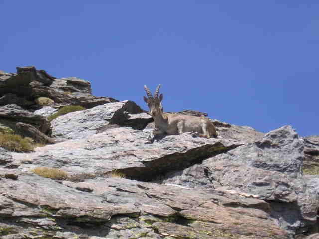
So I decided to go part way towards Pulpito, and then deadhead (can't call it bushwacking, no bushes to whack) across to the trail that goes up towards Mulhacén). On this deadhead, I had a fortuitous encounter with an apparently fairly rare Iberian mountain deer. No fear, I have some good pictures, in spite of most of them being skittish. One most kindly posed.


I eventually returned to the mountain hut, shared my find with the guy (thus finding out what it was...), and headed back down to my pack.

The rest of the day was a very long slog in the hot sun along a high trail heading down the ravine. There was almost no cover, and eventually there was an outcrop near which I could set up camp in the shade.
One last view of Mulhacén.

No cover.


I slept al fresco that night, the stars were wonderful.

Hiking Las Alpujarras, day 1

I arrived in the village of Capileira around 1 PM. In southern Spain, this is not a great time to start hiking, but I had little choice.
The village of Capileira.

Where we're headed.


I headed up the valley towards the higher terrain. This is basically a very long ravine, with what they fancifully called a river running down it. It had decent flow, but in the White Mountains of New Hampshire it wouldn't be much more than a brook.


I stuck to a trail that was at the bottom of the valley, where there were trees (proximity to the water...) and thus shade. I saw figs ripening. I saw some sort of deer-like critter.


I saw a small hydro power station about 1/2 way up. But there still wasn't always enough shade.


View of Mulhacén.


I had hoped to make it all the way to a mountain hut at the top of the ravine, but I was totally beat from carrying 30lbs of pack in the heat, and stopped early to make camp. I found a nice secluded place away from the trail, but not too far from the water, and settled down.

At one point, somewhere around 9:30 or so, I heard what sounded like a child screaming.

It turned out to be a shepherd making his way down the trail, accompanied by a donkey, which was the source of this unexpected noise. I mostly ignored this, and enjoyed the sunset.


I had an otherwise uneventful night, except I kept sliding down the hill, since the tent was pitched on a noticeable slope.