Monday July 2
Today I drove from Spruce Knob to the parents' abode outside Philadelphia. Once I exited West Virginia, it largely became the typical mass of undifferentiated interstates where the only things that change from one exit to the next are the labels on the hotels, eateries, and gas stations (which are repeated every 2-4 exits anyway...)
Wednesday July 4
After spending the 3d visiting with the folks, I headed homeward, still following the Appalachians to some rough extent. The day was gray and often rainy. It started with a drive up the Delaware Valley, including the Delaware Water Gap, and a near miss to the New Jersey High Point, which I did not visit since it was thunderstorming at the time.
The drive continued up into the Catskills of New York, including passing through Ashokan, site of a well-known traditional dance camp.
The drive came to a merciful end in Hudson, NY, where, at least in part due to the weather, I decided motelling was better than camping.
Home (or at least, Herself's home, as I was still homeless) was reached on the 5th.
Showing posts with label appalachians. Show all posts
Showing posts with label appalachians. Show all posts
Thursday, August 16, 2007
Cruising West Virginia
Saturday June 30
This was a day for driving through scenic eastern West Virginia. It began with a stretch of the New River Gorge, and continued roughly north and east from there. This area is generally quite rural, and the going alternates between expansive views and curvy roads up or down the sides of ridges -- this is the southeastern Alleghenies. I eventually ended up at Spruce Knob Lake Campground, a 3700-foot remote campground in the Spruce Knob-Seneca Rocks National Recreation Area. The principal recreations here appear to be fishing and rock climbing.
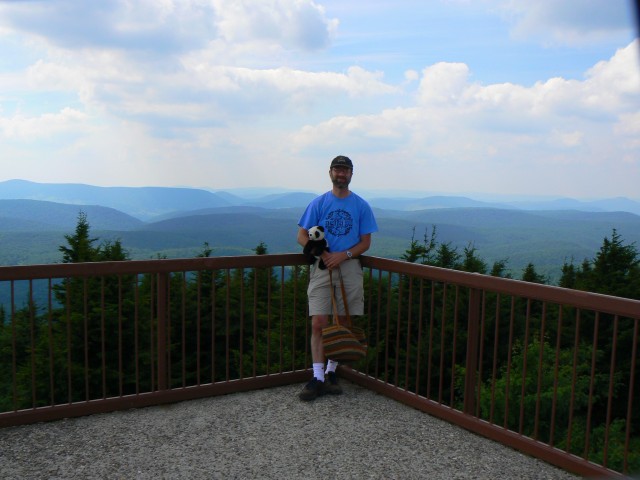
Spruce Knob, for those keeping score, is the highest point in West Virginia. (The score for this trip is five high points: Virginia, North Carolina, Tennessee, South Carolina, and West Virginia. I drove up the last three.) It has great views, which are wonderfully captured in my previous blog entry and mislabelled as views from the Pipestem Resort observation tower. The summit was a wonderful place to spend an evening...
Sunday July 1


This day was again spent cruising in West Virginia, and also western Maryland. It started early at the Seneca Rocks, a promining outcrop that is a popular climbing destination. (Eric, take note.) I merely hiked up to a viewing area to see what was to be seen, which included some local wildlife.
In the area near the Maryland border, I encountered a windmill farm -- I wish I had pictures, there were actually some interesting views of them from the road. (Opponents of wind energy like this project, take note.)
This was a day for driving through scenic eastern West Virginia. It began with a stretch of the New River Gorge, and continued roughly north and east from there. This area is generally quite rural, and the going alternates between expansive views and curvy roads up or down the sides of ridges -- this is the southeastern Alleghenies. I eventually ended up at Spruce Knob Lake Campground, a 3700-foot remote campground in the Spruce Knob-Seneca Rocks National Recreation Area. The principal recreations here appear to be fishing and rock climbing.
Spruce Knob, for those keeping score, is the highest point in West Virginia. (The score for this trip is five high points: Virginia, North Carolina, Tennessee, South Carolina, and West Virginia. I drove up the last three.) It has great views, which are wonderfully captured in my previous blog entry and mislabelled as views from the Pipestem Resort observation tower. The summit was a wonderful place to spend an evening...
Sunday July 1

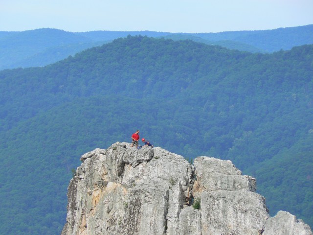

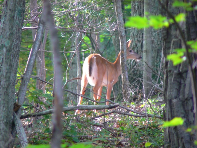
This day was again spent cruising in West Virginia, and also western Maryland. It started early at the Seneca Rocks, a promining outcrop that is a popular climbing destination. (Eric, take note.) I merely hiked up to a viewing area to see what was to be seen, which included some local wildlife.
In the area near the Maryland border, I encountered a windmill farm -- I wish I had pictures, there were actually some interesting views of them from the road. (Opponents of wind energy like this project, take note.)
Sunday, August 12, 2007
North to West Virginia
Friday June 29
This was a day spent winding northward through the mountains of North Carolina, a jaunt along I-81 in Virginia, and more winding through to hills of eastern West Virginia. Parts of the day featured rain, including not too long after arrival at Pipestem Resort State Park.


This park features a gorge on the Bluestone River. There is a trail down to a viewpoint (descent of about 800 feet), as well as a gondola that goes down to facilities along the river. I hiked down this trail for the views, but had to endure a little rain. Bear was fortunately spared dampness by clever use of the umbrella.


There was also an observation tower near the park entrance that had some lovely views.
Friday, August 10, 2007
A day in Asheville
Thursday June 28
[Sorry about the delay in the trip details. Moving interfered, but photos are now up in the earlier trip entries.]
This day was a rest day to recover from the previous 4 days of hiking. A lazy day was spent, including a slow stroll through Asheville to photograph some of its architectural variety.


First up, this is the courthouse.


I think this is/was a bank building.


Interesting detail on local retail/commercial building.


Outside the convention center are these statues capturing local music and dance tradition.
Dinner was at Limones in Asheville, and featured quite possibly the smoothest chocolate mousse I've ever had. Yum.
[Sorry about the delay in the trip details. Moving interfered, but photos are now up in the earlier trip entries.]
This day was a rest day to recover from the previous 4 days of hiking. A lazy day was spent, including a slow stroll through Asheville to photograph some of its architectural variety.


First up, this is the courthouse.


I think this is/was a bank building.


Interesting detail on local retail/commercial building.


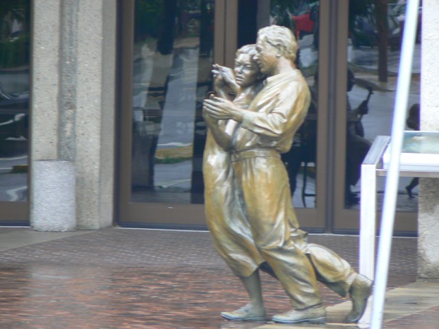
Outside the convention center are these statues capturing local music and dance tradition.
Dinner was at Limones in Asheville, and featured quite possibly the smoothest chocolate mousse I've ever had. Yum.
Thursday, June 21, 2007
The beautiful Blue Ridge
Monday, June 18


Today I drove down a stretch of the Blue Ridge Parkway. This scenic road stretches from Northern Virginia to southwestern North Carolina. Today I drove about 100 miles, taking about 4 hours, including stops to enjoy views and such along the way. I made my way west along an extremely windy stretch of US 58 to Virginia's Grayson Highlands State Park.This gem of a park contains some nice open highlands, has facilities for camping and horseriding, and is also along the Appalachian Trail. I stayed in the campground for the night, but not before enjoying a spectacular sunset view from a point called (imaginatively enough) Little Pinnacle. Along the way I spotted rabbits and deer.
The park is adjacent to the Mount Rogers National Recreation Area, where I spent some time the next day.
Tuesday, June 19
This morning featured a bright and early start. Since a chance of thunderstorms was forecast for this afternoon, I thought it wise to tackle Mount Rogers early today. I actually managed to break camp and be at the trailhead by 7:15. I know, not impressive, unless you know how much I like getting up some mornings.


The hike to Mount Rogers (5729 feet, highest point in Virginia) was about 8 miles round trip, with about 1000 feet of elevation gained. Parts of the route are on the AT. The landscape was fairly open, often with views mostly in southerly directions. The primary large inhabitants of the area seem to be wild ponies, some of which were not shy at all. (At least they're not as dangerous as bear, which are also a presence along much of the Appalachians.) The summit of Rogers is wooded, but the whole rest of the hike was very pleasant.
The weather was overcast with pockets of sun and drizzle. I returned to my car around 11:30.
From Grayson Highlands, I drove further down the very twisty US 58 to Abingdon, VA, where I picked up I-81 and made my way on to Asheville, NC. After ensconcing in my hotel on the outer edge of town (and also napping), I headed downtown for dinner and ice cream. I find that Marble Slab serves pretty nice ice cream.
Wednesday, June 20
My first full day in the Asheville area, and time to do some research. I'm interested in hiking Mount Mitchell (highest point in the eastern US) and Clingman's Dome (scenic high point in the Smoky Mountains). I decide to drive more of the Blue Ridge Parkway toward the main NC entrance to Great Smoky Mountain National Park, to acquire maps and information about permitting. Along the way, I stop to summit Mount Pisgah (not to be confused with a church or a similarly named peak in Pennsylvania.) This was a short hike, 3 miles RT and 700 feet up to the summit.
 I met a middle-aged couple and his father, who had originally been on the summit 40 years before. They had interesting insights into the changes in the summit area (which features a TV transmission tower among other things).
Lunch was a southern affair at The Tupelo Honey Cafe. Toasted tomato and cheese sandwich with a side of fried okra. Yum.
Dinner was also a local affair, at the Early Girl Eatery. Once again Yum, but not much Russell-friendly here.


The park is adjacent to the Mount Rogers National Recreation Area, where I spent some time the next day.
Tuesday, June 19
This morning featured a bright and early start. Since a chance of thunderstorms was forecast for this afternoon, I thought it wise to tackle Mount Rogers early today. I actually managed to break camp and be at the trailhead by 7:15. I know, not impressive, unless you know how much I like getting up some mornings.


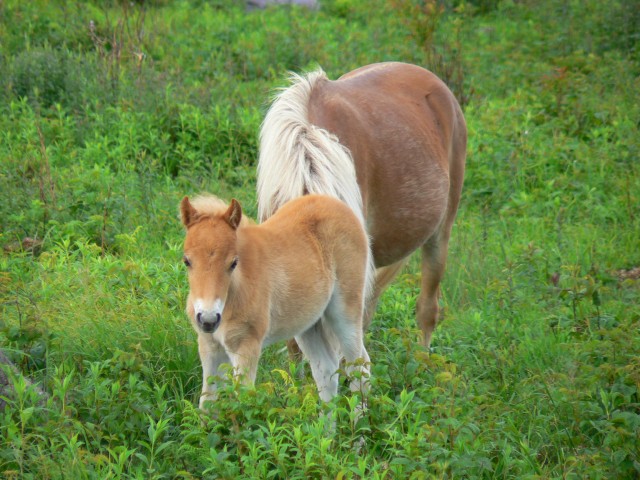

The hike to Mount Rogers (5729 feet, highest point in Virginia) was about 8 miles round trip, with about 1000 feet of elevation gained. Parts of the route are on the AT. The landscape was fairly open, often with views mostly in southerly directions. The primary large inhabitants of the area seem to be wild ponies, some of which were not shy at all. (At least they're not as dangerous as bear, which are also a presence along much of the Appalachians.) The summit of Rogers is wooded, but the whole rest of the hike was very pleasant.
The weather was overcast with pockets of sun and drizzle. I returned to my car around 11:30.
From Grayson Highlands, I drove further down the very twisty US 58 to Abingdon, VA, where I picked up I-81 and made my way on to Asheville, NC. After ensconcing in my hotel on the outer edge of town (and also napping), I headed downtown for dinner and ice cream. I find that Marble Slab serves pretty nice ice cream.
Wednesday, June 20
My first full day in the Asheville area, and time to do some research. I'm interested in hiking Mount Mitchell (highest point in the eastern US) and Clingman's Dome (scenic high point in the Smoky Mountains). I decide to drive more of the Blue Ridge Parkway toward the main NC entrance to Great Smoky Mountain National Park,
 to acquire maps and information about permitting. Along the way, I stop to summit Mount Pisgah (not to be confused with a church or a similarly named peak in Pennsylvania.) This was a short hike, 3 miles RT and 700 feet up to the summit.
 I met a middle-aged couple and his father, who had originally been on the summit 40 years before. They had interesting insights into the changes in the summit area (which features a TV transmission tower among other things).
Lunch was a southern affair at The Tupelo Honey Cafe. Toasted tomato and cheese sandwich with a side of fried okra. Yum.
Dinner was also a local affair, at the Early Girl Eatery. Once again Yum, but not much Russell-friendly here.
Monday, June 18, 2007
Driving down the Appalachians
Saturday, June 16
Leave Cambridge 9:45. Arrive Pine Grove Furnace State Park (PA) about 6:15. In between I noticed that Russell isn't the only one going to or through Newfoundland. (Newfoundland, PA is just east of Scranton.)
Unbeknownst to me, Pine Grove Furnace State Park is the semi-official 1/2-way point on the Appalachian Trail! I chatted with some through-hikers while there, and read the register. The camp store will give free 1/2 gallons of ice cream to anyone who can finish them (I think in some modest time period like 30 minutes or 1 hour.)
The reason for this state park's existence is that it was the site of an early iron works (18th century I believe). All that's left really is a large chimney-like structure.
Sunday, June 17
In the morning, I hiked up to a local vista (about 1 hour each way). The entire area is forested. After said hike, drove on to Gettysburg, about 25 miles away. Drove around the battlefield, which is studded with monuments and plaques show who did what to whom when, and where, as well as monuments placed by states or state-level organizations to commemorate their fallen. On both sides, of course.
From Gettysburg, drove on the Harper's Ferry, WV, where I wandered down to the river (Shenandoah, I believe) for a view and some lunch. Drove on (and on), eventually picking up I-81 down the Shenandoah Valley. Got off near Natural Bridge, spent the night at a campground just off the Blue Ridge Parkway.


Leave Cambridge 9:45. Arrive Pine Grove Furnace State Park (PA) about 6:15. In between I noticed that Russell isn't the only one going to or through Newfoundland. (Newfoundland, PA is just east of Scranton.)
Unbeknownst to me, Pine Grove Furnace State Park is the semi-official 1/2-way point on the Appalachian Trail! I chatted with some through-hikers while there, and read the register. The camp store will give free 1/2 gallons of ice cream to anyone who can finish them (I think in some modest time period like 30 minutes or 1 hour.)
The reason for this state park's existence is that it was the site of an early iron works (18th century I believe). All that's left really is a large chimney-like structure.
Sunday, June 17
In the morning, I hiked up to a local vista (about 1 hour each way).
 The entire area is forested. After said hike, drove on to Gettysburg, about 25 miles away. Drove around the battlefield, which is studded with monuments and plaques show who did what to whom when, and where, as well as monuments placed by states or state-level organizations to commemorate their fallen. On both sides, of course.
From Gettysburg, drove on the Harper's Ferry, WV, where I wandered down to the river (Shenandoah, I believe) for a view and some lunch. Drove on (and on), eventually picking up I-81 down the Shenandoah Valley. Got off near Natural Bridge, spent the night at a campground just off the Blue Ridge Parkway.

Subscribe to:
Posts (Atom)
