The Chisos Mountains are the central feature of Big Bend National Park, and there is plenty to see there. Some parts are readily accessible by day hikes lasting 4 hours or less.
The mountain chain was formed by volcanic activity, followed by erosion of surrounding softer limestone. This gave the chain the shape of about a half dozen mountains surrounding a high valley, which is called The Basin. The Basin contains a cluster of services for the park -- lodge with accomodation, store, ranger station, campground, and is accesible by a CCC-construced road. (This means sharp switchbacks and the like.)
One of the most striking features of the Basin is the point at which water drains out of it. This V-shaped cut ends at what is called a "pour" -- this is just a waterfall that is often, or generally, dry. The first picture is a view of the Window from inside the Basin, the second is the view from the desert outside the mountains.
While they were at it, the CCC crew built a trail called the Lost Mine Trail. This is probably the most spectacular day hike in the park.
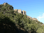
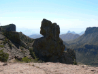
One of the more prominent and spectacular peaks in the mountains is called Casa Grande, and is visible in numerous photos, including these two.
Next update in a few days -- I will be in Big Bend Ranch State Park. (I have more pictures of the national park, so stay tuned for those!)
Subscribe to:
Post Comments (Atom)


No comments:
Post a Comment