Showing posts with label hiking. Show all posts

Monday, July 09, 2007

Clingman's Dome

Sunday June 24 to Wednesday June 27

On a fine warm North Carolina morning I set out to climb Clingman's Dome. Here are a few factoids about it, before we get started:

  • It's the highest point on the Appalachian Trail.

  • It's the highest point in the state of Tennessee.

  • Its summit observation tower is pretty close to ADA-accessible. Wheelchairs and stroller will make it, but not without assistance (the steep grade, mostly)

  • It's a great place to see the Smoky Mountains

  • Other than the access road, it's probably a 20-mile round trip (and at least 3-4000 feet of elevation) to the summit.


The National Park authorities require (free) permits before going into the backcountry. This is probably a Good Thing, since they know where to look for you. Camping in the backcountry is free, and restricted to campsites, most of which are fairly basic -- fire grates, food-hanging cables (to bearproof your site), some nearby water, and flat ground for your tent. The food-hanging cables were a new contraption to me, but easy to use.

Day 1 started with a brief 2+ hour hike (with full pack, thank you), to camp 74, which is near to Fontana Lake. After establishing camp, I spent the afternoon alternating between swimming in the lake (which was about 2-3 feet below "normal", and thus not that attractive, and fully exposed to summer sun), and relaxing in camp (shaded, moderately cool, but buggy).

Some of the trails in the park are open to horse-riding. This would be a recurring "feature" of the trail -- avoiding the horse droppings.

Day 2 was the first half of the Big Push: climb up about 2500' with a full pack, over a distance of about 8 miles. This was accomplished in about 6 1/2 hours, made exciting by a significant number of stream crossings (all manageable, but some were a fair amount of work when carrying a full load), and one ornery rattlesnake. The day ended at camp 68, where camp was erected in near-record time to be ready before rain arrived.

Day 3 was the second half of the Big Push: climb another 2500' with a day bag, an 8 mile round trip, plus another 2-3 miles of downhill under load to camp 69. The summit was a typical tourist-infested summit, but the views that day were quite nice (probably due to the rains of the day before).

Day 4 was the return to civilization -- about 8 miles of mostly downhill, but a spurt of up-and-down at the very end that is usually annoying because the muscles are all saying "we like going down, thank you".

After 3 1/2 days of not showering, hotel rooms are mighty nice.

Dinner was at Mela, a fine Indian restaurant in Asheville. I had quite possibly the best (certainly the freshest) Shahi Paneer I've ever had.

Happy trails!

Saturday, June 23, 2007

Asheville and Mount Mitchell

Thursday June 21

This day was partly a logistics day. Some necessary shopping, some supplies for at least tomorrow's assault on Mount Mitchell. I also visited the Folk Arts Center, which has nice displays and sales of contemporary regional folk arts, and a cool display on the design and construction of the Blue Ridge Parkway, going into some detail on the design principles that make the road as attractive as it is. I then drove on to Black Mountain, a small town outside Asheville with a one-street walkable downtown. Good for lunch, a haircut, and the necessary purchase of cooking gas for the upcoming trek into the Smokies.

Dinner was at the Laughing Seed Cafe, a place definitely Russell-unfriendly. Which means I liked it.

Friday June 22

This morning featured a hike up the highest mountain east of the Mississippi. Mount Mitchell is, amazingly enough, not on the Appalachian Trail, but it has lovely views out to the Smokies. Unfortunately, the very top of the summit was closed off due to the reconstruction of the observation platform.

Did I mention there was a road up to the summit area, and a concession stand? I actually hiked from further down, near where the access road meets the Blue Ridge Parkway. The trail featured some nice (if slightly after-peak) rhododendrons.

Dinner was at the Ophelia's World Cafe. It was good, but I really liked the other places I've eaten better.

Next update will not be until probably next Thursday, due to four-day hike into the Smokies.

Happy Trails!

Tuesday, December 05, 2006

Springtime in the Andes

It's really pretty here.


On Sunday morning I caught a late-morning bus to a small satellite community called Colonia Suiza. This is basically a strip of mostly tourist-oriented things (campgrounds, restaurants, artsy shops) along a dirt road. For me, it was the jumping-off point for a 5-hour hike up to a mountain refugio called Refugio Italia, next to a mountain tarn called Laguna Negra. The first 3.5 hours were along a mountain stream with gently increasing elevation. The woods were generally similar to what I encountered in Parque Huerquehuay in Chile, only the coigues trees were generally smaller. After those 3.5 hours, I reached a small campsite, and could see the falls.

Going up probably 200m.

A Canadian hiker coming down had told me to expect snow. As the trail wound its way up the side of the mountain on one side of the falls, there was snow. I tell ya, crossing snow fields that descend steeply for 30m is not always fun in the springtime. If the snow decides to slip, you go with it. To the rocks (usually) below.

But the refugio was reached without incident.

Those of you who have been in White Mountain huts will know what sort of service those provide: large dorm rooms, a staff of four or five, hearty dinner and breakfast, all for about $60.

This was not that. There was, at the time, only a young lady from Buenos Aires as caretaker. The capacity was about 60. Dinner and lodging cost A$38 (about US$13). The place was poorly heated (one central stove that madam caretaker did not feed too much), but it was shelter from nearly-continous 15mph winds. There was me, the caretaker, and an Argentine couple. An American couple popped in to say they were camping (!) nearby. I saw where they put their tent, but I'm still wondering how easy it was for them to cook dinner, given the winds. The caretaker said that the high moutain routes were still snow-bound and generally dangerous due to spring avalanche-like conditions. This did not stop one Aussie clown from making such a traversal (I passed him on his way down near the refugio, decked out in full snow/ice gear.)

Laguna Negra was still mostly frozen over. The temperatures at night were probably above freezing, but not by much. I was toasty warm in the sleeping bag, with the usual I-don't-want-to-leave-it problem in the morning.

Morning was actually relatively wind-free. I took about 90 minutes to explore the shoulder of one of the nearby peaks that seemed attainable without winter or mountaineering gear. It wasn't, but I got a great view of one of the other local peaks, which is named Cerro Catedral for a very good reason. Since my pictures were stolen , you can look at another traveler's pictures to get an idea.

The hike down was uneventful, if a bit rushed, as there are few buses going through Colonia Suiza each day.

The day yesterday was capped with one thing I like about Argentina: a three-course dinner with 1/2 bottle of wine for about $15. Yum.

Today is a relaxaday, hanging about Bariloche. Tomorrow begins the slog back toward Santiago (requiring about 16 hours in buses, with about 7 hours of layover in Osorno Chile).

Hasta luego!

Trip Directory Trip Directory Next Trip Page

Friday, December 01, 2006

sliding down a volcano

So yesterday I ascended Volcán Villarrica. I went with a group of 4 Aussie lads, 2 Israeli lasses, and a crusty German guide named Klaus (who brought skis). There is a ski area on the volcano, to whose base we were driven. We then took the ski lift (for an extra CLP5000, about $10) to a height of about 1800 meters. From there we began trekking uphill, through snow, in a long, occasionally broken chain of ants.


Did I mention there were about 200 other people on the mountain?

We stopped about once an hour for a break. The edge of the caldera is about 2870 meters, and each hour we covered about 250 meters of altitude, at a fairly slow pace. (It felt slow to my leg muscles, which like to go faster, but about right for my lungs, which usually complain.) Early on, we had a brief lesson in how to use the ice axe we were each given. Given that the mountain (especially at higher altitudes) is cone-shaped, there aren't many features to stop you from falling a Long Way.

The views on the way up, and on the caldera edge, were outstanding. We did not go to the actual summit (which was on the far side of the caldera from where we came up). But we got a really good look partway into the crater, which was deep enough that no lava was visible. But the steam wafting up from the crater did come with its own peculiar, umm, stench, which generally set people coughing.

The descent was a ride. Near the top, conditions were very icy, but once we got a bit further down, we did a series of progressively longer slides on our butts. Imagine you are in something resembling a water slide. Your means of control are (1) your feet, and (2) your ice axe. Both provide some means for controlling speed and direction.

The sliding was most fun higher up on the mountain, where the snow was firmer. As we got lower and lower, the snow got more and more slushy, and we ended up pushing a lot of it down the mountain with our butts.

Total time of ascent: about 3:45. Total time of descent: about 1:45.

Wheee.

Today I caught a bus to Valdivia, which is near the coast a bit further south than Pucón. From here, I plan to go to Bariloche in Argentina, and then on to a smaller place a bit south of there.

Hasta luego!


Trip Directory Trip Directory Next Trip Page

Wednesday, November 29, 2006

Parque Nacional Huerquehue

Parque Nacional Huerquehue is a smallish national park not far from Pucón (see previous entry). There are three buses a day -- 8, 1, 4. Courtesy of problems in acquiring a tent, I missed the 8 bus, and ended up on the 1, which reached the park about 2:15. There is a campground in the center of the park, a five-plus hour hike from the gate. While I had originally planned to spend two nights there, I opted for discretion and stayed at the campground near the gate.

This turned out to be a Good Thing, for reasons that shall become clear. This campground had wooded sites, and was located near Lago Tinquilco, a smallish lake partly within park boundaries. I had the entire grounds to myself, and enjoyed a beautiful sunset over the lake.

The next day I hiked up into the higher grounds of the park, where there are more small lakes and waterfalls. This was an absolutely beautiful area -- wooded, with native trees abounding. There are several types of trees here that have trunk diameters in excess of 10 feet. I think it makes doing trail work here exciting...

The highlight of the day (and the next day too) was Lago Toro, which is a picture postcard waiting to be sold.
Someone else's picture

Late in the afternoon I arrived at the other campground, at which point I really appreciated my decision to stay in the other one. This one was essentially a hunk of pasture (complete with cow pies, but this has been experienced before...), with little redeeming character. They claim there is a "refugio" here, but all I saw was a very low leanto that on a good night might allow 3 people under it. They also claim to have an outhouse. The sad excuse of an outhouse was in a sad state of neglect, being full of trash, and generally unusable. Fortunately, there was a shovel-head in the camp leavings nearby, which I was able to use for dealing with things normally done in an outhouse.

I spent the evening in conversation with an Italian woman who was spending several days at this godforsaken campground, whose only benefit is its central location, so that she could fully explore the park.

The next day (which would be today!) I made a brief early-morning excursion to a small lake nearby, and then hightailed it back the way I came, more-or-less, to eventually return to Pucón.

Tomorrow I climb a volcano.

Hasta luego!

Trip Directory Trip Directory Next Trip Page

Wednesday, September 21, 2005

Garfield (NOT the stupid cartoon cat)

Went for a modest (6 1/2 hour) hike today. (Surrounded by 2 1/2 hours of driving on either side as is fairly usual...) It was cold (40s) and windy on the summit, but I was prepared.

That's about as nice as the visibility ever gets these days.


That's Owl's Head behind me. The wall I'm holding up was once part of the foundation to a summit building (fire warden's house or fire tower) here.


Tomorrow, back to work on my Tom Sawyer project. One day of nice weather, hope I can make the most of it.

Sunday, August 14, 2005

Hiking Las Alpujarras, day 3 and return to Granada

The last day of the Las Alpujarras hike was fairly easy. Except for the almost getting lost part.

An early-morning walk downhill.


I estimated that I was about 1-1.5 hours outside Capileira when I camped. With a typically early start (great for avoiding heat), I made pretty good time, largely downhill. However, it soon became clear there were more trails and roads on the ground than on my map.

Don't you just love when that happens?

Well, signs sometimes help.


Of course, every once in a while the village would appear, little white houses dangling on the side of the ravine. Oh yes. The villages here are not at the *bottom* of the ravine, they are 1/3 to 1/2 way up the side. Go down too far, and you may end up going back up, something the 30lb pack was weighing in against.

I eventually found a friendly shepherd to make sure I was on the right track. I was in Capileira around 11. Considering the bus wasn't until 4 or so, I headed down the valley some more, and waited in another village further down the valley.

Not Mulhacén for a change, but a mountain across the valley.


A nice resting spot on the way down.


The bus arrived, and without incident (crashing through the weight-limited bridge en route would be a not-fun incident), arrived back in Granada.

A short cab ride later, and I was checking into the Hotel Guadalupe, a fairly short walk from the Alhambra. After I was done checking in, I was approached by Karen Duffy, one of the Earthwatch volunteers I would be spending the next two weeks with.

En route to (and after) dinner with Karen, her daughter Sara, and Bri Lehman, I took a few pictures of the Alhambra.


Hiking Las Alpujarras, day 2

Another view of Mulhacén.


I hiked up to the bowl at the top of the ravine. At this point there was a building of the sort marked on the map as a 'cortijo' which appears to be localese for farm/land structures.


I wonder what this is. Perhaps one of the fiber-readers can comment.


Man, did we come all that way?


They appear to be used mostly for animals, but some of them appear to also have rooms for the shepherds to stay in. I ditched the big pack there, and continued on up with just a day bag, since there was a trail junction here.

Man, did we come all that way?

Just making sure where we are.


After about 45 minutes I reached the mountain hut. This hut is actually accessible by a road that comes over one of the mountain shoulders, and was reminiscent of huts I've seen in the Alps.

I had a short chat (if you can call my broken Spanish chatting) with the proprietor, and realized that Mulhacén was not reachable given my time constraints, and realistically, neither was a neighboring peak Pulpito. (In White Mountain terminology, Pulpito was probably not a proper peak. It was more like Boott Spur, a high bump on one of Mulhacén's shoulders.)

View of El Vieja, the big peak next to Mulhacén.


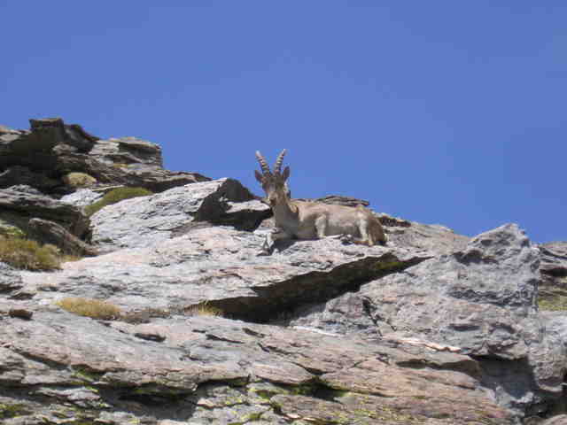
So I decided to go part way towards Pulpito, and then deadhead (can't call it bushwacking, no bushes to whack) across to the trail that goes up towards Mulhacén). On this deadhead, I had a fortuitous encounter with an apparently fairly rare Iberian mountain deer. No fear, I have some good pictures, in spite of most of them being skittish. One most kindly posed.


I eventually returned to the mountain hut, shared my find with the guy (thus finding out what it was...), and headed back down to my pack.

The rest of the day was a very long slog in the hot sun along a high trail heading down the ravine. There was almost no cover, and eventually there was an outcrop near which I could set up camp in the shade.
One last view of Mulhacén.

No cover.


I slept al fresco that night, the stars were wonderful.

Hiking Las Alpujarras, day 1

I arrived in the village of Capileira around 1 PM. In southern Spain, this is not a great time to start hiking, but I had little choice.
The village of Capileira.

Where we're headed.


I headed up the valley towards the higher terrain. This is basically a very long ravine, with what they fancifully called a river running down it. It had decent flow, but in the White Mountains of New Hampshire it wouldn't be much more than a brook.


I stuck to a trail that was at the bottom of the valley, where there were trees (proximity to the water...) and thus shade. I saw figs ripening. I saw some sort of deer-like critter.


I saw a small hydro power station about 1/2 way up. But there still wasn't always enough shade.


View of Mulhacén.


I had hoped to make it all the way to a mountain hut at the top of the ravine, but I was totally beat from carrying 30lbs of pack in the heat, and stopped early to make camp. I found a nice secluded place away from the trail, but not too far from the water, and settled down.

At one point, somewhere around 9:30 or so, I heard what sounded like a child screaming.

It turned out to be a shepherd making his way down the trail, accompanied by a donkey, which was the source of this unexpected noise. I mostly ignored this, and enjoyed the sunset.


I had an otherwise uneventful night, except I kept sliding down the hill, since the tent was pitched on a noticeable slope.